
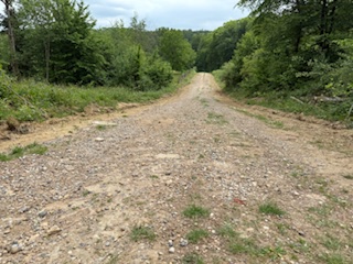
Challenging for wheelchairs
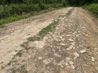
The path is a forestry track, though on the occasions when forestry vehicles are using the track the path will be closed to visitors. The first part of the path descends from Hastings Wood to the stream is 4 metres wide, has gradients up to 9% and cross falls of between 1% and 5%, but increasing towards the edges. The surface is compacted stones, which is loose and uneven in places. The path heading uphill from the stream is over 5 metres wide, steep cambers of up to 30% on both edges reduce the usable width to about 3 metres – some powered off-road wheelchairs entering the cambered edges risk tipping or getting stuck. The usable path has cross falls of between 3% and 10%. The surface is compacted mud and stones, with sections of rubble and bricks making it uneven in places. The highest path gradient is about 10% until the slope approaching the gate at the top of the path, where the gradient rises to about 20%.
This Forestry track is approximately 360 metres long with a Compacted mud and stone (some over 10cm) surface
The narrowest point: 300 cm wideSteepest gradient: 20% (1:5), the surface under steep sections is Mud and stones
Shared with: Forestry vehiclesWaymarked or signposted: YesHas raised edges: NoHas contrasting colours: No
Location: West Sussex
Grid reference: TQ 36795 34667
W3W: ///eased.enjoyable.falls
Added by: Matt OverdVerified by: Matt OverdLast reviewed: May 2025ID: GRAV034
Grid reference: TQ 36795 34667
W3W: ///eased.enjoyable.falls
Added by: Matt OverdVerified by: Matt OverdLast reviewed: May 2025ID: GRAV034