Challenging for wheelchairs
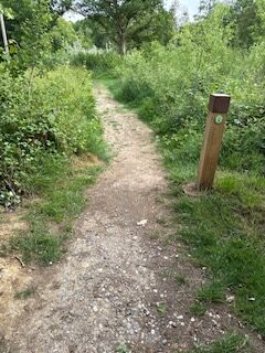
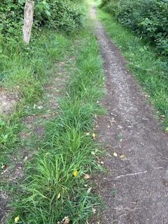
Path leaves the Vowels Lane car park behind the sign on the green William Robinson Trail. Initially a gradient of about 6% across fall of about 6% and the width of about a meter. The path is a mud surface which would become muddy after rain. It is uneven with a few ruts from the mud. As the path rounds the corner, the usable width drops below 1m as the path drops to one side, though there is some useable verge. At TQ 36137 34986 the path surface becomes stones in compacted mud. Stones are larger than 4 cm but are compacted into the mud. Some broken tarmac creating large stones bigger than 4 cm on the path. Gradient increases to 13% for a short section with a cross fall of about 3%. Overall, this path is a solid construction. At TQ 36231 34947 the path width increases to 2 m including usable verge. After the junction with path 45 the path is made of stone, mud and grass path with vehicle grooves. It is 2 metres wide plenty. Near TQ36499 35010 the gradient increases to 9% the path becomes more uneven with a steep drop off to the left of about 20% creating a width usable of about 1 metre down the centre with the risk of toppling to the left.


Location: West Sussex
Grid reference: TQ 36106 35013
W3W: watching.expectant.stuffing
Added by: Matt OverdVerified by: Matt OverdLast reviewed: May 2025ID: GRAV069
Grid reference: TQ 36106 35013
W3W: watching.expectant.stuffing
Added by: Matt OverdVerified by: Matt OverdLast reviewed: May 2025ID: GRAV069